The Two Islands a Day Apart in the Bering Strait
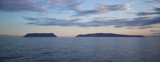
Big Diomede and Little Diomede sit 2.4 miles apart. The clock on one is 21 hours ahead of the clock on the other.
Big Diomede belongs to Russia. Little Diomede, 2.4 miles to the southeast, belongs to the United States. The International Date Line runs through the water between them. Stand on Little Diomede on a Tuesday morning and look across the strait, and the rocks you can see are already in Wednesday afternoon — Big Diomede's local time is 21 hours ahead, 20 in summer.
The nicknames followed: Tomorrow Island and Yesterday Island. They aren't poetic. The clocks really run that far apart, because each side keeps the time of the country it belongs to, and the line that separates calendar days happens to thread the gap.
The islands didn't always sit on opposite sides of a Cold War. Inupiat families lived on both rocks for centuries and crossed routinely. In 1948 the Soviet government cleared Big Diomede, relocating the indigenous population to the Chukotka mainland and turning the island over to a military base. The civilian crossings stopped. Today Big Diomede has no permanent residents, only soldiers. Little Diomede had 77 people as of January 2023, most of them Inupiat, living in a single village on the island's western shore — the side that faces tomorrow.
In winter the strait freezes hard enough to walk, and an ice bridge usually forms between the two islands. It is one of the few places on Earth where you could, in theory, step from one calendar day into the next on foot. The border guards on the Russian side make sure no one tries.
Make Recess yours.
Sign in to save the ones you loved, never see the same thing twice, and tell us what you want more of.